Trail Walking Saint-Antoine l'Abbaye - Lac Chapaize / St Antoine - Photo
© OpenStreetMap contributors
Length
Length
7.1 km
Max alt
Max alt
442 m
Uphill gradient
Uphill gradient
168 m
Km-Effort
Km-Effort  
9.4 km
Min alt
Min alt
349 m
Downhill gradient
Downhill gradient
170 m
Boucle
Boucle
Yes
Creation date :
2023-03-30 17:53:51.144
Updated on :
2023-03-30 17:53:53.019

(0 Reviews)

Walking
Walking
2h07
Difficulty : Medium

Scan this QR Code to open this trail in the SityTrail application

FREE GPS app for hiking

Logo SityTrail SityTrail

IGN / Geographical institutes

Download SityTrail from the App Store Download SityTrail from Google Play

Logo SityTrail SityTrail World

The world is yours!

Download SityTrail from the App Store Download SityTrail from Google Play Download SityTrail on Huawei AppGallery

About

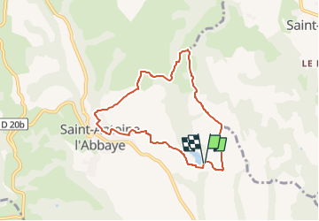
Trail Walking of 7.1 km to be discovered at Auvergne-Rhône-Alpes, Isère, Saint-Antoine l'Abbaye. This trail is proposed by Gaillardenis.

Description

Départ au lac Chapaize/Parc de loisir Miripili
La montée se fait progressivement par une petite route très peu fréquentée
Descente pour rejoindre le ruisseau
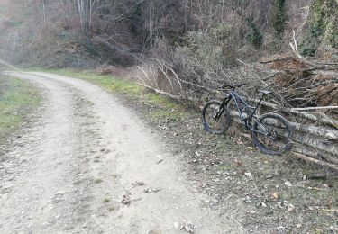
Après l'avoir emjambé remonter par une belle piste jusqu'à retrouver la route
Rejoindre l'abbaye
Visite de l'abbaye et du musée (gratuit)
L'abbaye est à mi chemin
Le retour se fait par un petit sentier au-dessus du parking  avant de rejoindre "la route du lac"
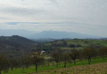
Sur le parcours de nombreux jolis points de vue sur la chaîne du Vercors..et Sud Drôme

Elevation profile

Positioning

Country:
France
Region :
Auvergne-Rhône-Alpes
Department/Province :
Isère
Municipality :
Saint-Antoine l'Abbaye
Location:
Saint-Antoine-l'Abbaye
Start:(UTM)
675809 ; 5004333 (31T) N.

Trails nearby

Trail Mountain bike Chatte - De Chatte à St Antoine en passant par Chevrière - Photo
Mountain bike
gilder89

Mountain bike

Very difficult
(1)
Chatte, Auvergne-Rhône-Alpes, Isère, France
44 km | 60 km-effort
3h 53min
Yes
Trail Walking Saint-Antoine l'Abbaye - saint Antoine l abbaye - Photo
Walking
nano38

Walking

Very easy
(1)
Saint-Antoine l'Abbaye, Auvergne-Rhône-Alpes, Isère, France
6.9 km | 9.3 km-effort
1h 52min
Yes
Trail Road bike Chatte - chatte2 - Photo
Road bike
BELLETGE

Road bike

Very easy
(1)
Chatte, Auvergne-Rhône-Alpes, Isère, France
57 km | 71 km-effort
3h 18min
Yes
Trail Mountain bike Chatte - chemin du tram part1 - Photo
Mountain bike
Julien Rodriguez

Mountain bike

Very easy
Chatte, Auvergne-Rhône-Alpes, Isère, France
11.4 km | 14.1 km-effort
1h 16min
Yes
Trail Walking Saint-Antoine l'Abbaye - st. Antoine l'Abbaye - Photo
Walking
Bgi

Walking

Easy
Saint-Antoine l'Abbaye, Auvergne-Rhône-Alpes, Isère, France
21 km | 28 km-effort
5h 36min
Yes
Trail Walking Saint-Antoine l'Abbaye - cap'r à Dionay - Photo
Walking
bpc

Walking

Easy
Saint-Antoine l'Abbaye, Auvergne-Rhône-Alpes, Isère, France
8.7 km | 11.4 km-effort
1h 16min
Yes
Trail Walking Chevrières - Chevrieres fêtas - Photo
Walking
michelineguillot

Walking

Easy
(1)
Chevrières, Auvergne-Rhône-Alpes, Isère, France
13.3 km | 18 km-effort
3h 14min
Yes
Trail Walking Saint-Antoine l'Abbaye - Bourgeonnière départ Le Mouchet - Photo
Walking
brigitBB26

Walking

Difficult
Saint-Antoine l'Abbaye, Auvergne-Rhône-Alpes, Isère, France
11.4 km | 14.8 km-effort
4h 33min
Yes
Trail Horseback riding Saint-Antoine l'Abbaye - J4_boucle_St Antoine l'Abbaye foret de Thivolet 17/4 - Photo
Horseback riding
Juyagan

Horseback riding

Difficult
Saint-Antoine l'Abbaye, Auvergne-Rhône-Alpes, Isère, France
26 km | 34 km-effort
4h 31min
Yes


Close
My subscriptions